Database Field Definitions
Associated Natural Communities (plant):
OKNP natural communities where a rare species is or has occurred
Associated Pollinators (plant):
known pollinating organisms of a plant
Associated Rare Plants (natural community):
rare plants that have been observed in a community
Best Season for Identification (natural community):
ideal season for identifying a natural community based on the presence and ease-of-identification of the characteristic plants
Coefficient of Conservatism (C value) (plant):
value ranging from 0-10 indicating the fidelity of a species to intact, stable ecosystems with low values indicating tolerance to disturbance and high values indicating intolerance to disturbance. Plants with higher C values are sometimes referred to as conservative and those with lower C values are sometimes referred to as weedy. These values are provisional and expected to be updated in 2025 with a publication of the C values for the flora of Kentucky and Tennessee.
Common Name:
colloquial name or classification of an organism or natural community. See Natural Community Classification section below for more background on the development and naming conventions.
Community Summary (natural community):
a short synapsis of the key characteristics and most distinguishing features of a community
Composition (natural community):
dominant and characteristic plants of a natural community
Conservation (natural community):
summary of ongoing conservation information like rarity, threats and protection actions or needs
County:
county(ies) where OKNP has a mapped occurrence of a species or ecosystem in the Kentucky Natural Heritage Database. This may be unreliable for natural community distribution since mapped occurrences usually have to meet a higher threshold of quality to be mapped and natural community mapping is currently incomplete
Disturbance Regime (natural community):
natural disturbances influencing a natural community
Distribution (maps):
Maps depict documented occurrences from the Office of Kentucky Nature Preserves’ Natural Heritage Database (March 2025); species are mapped at the county level, distinguishing extant and historic records where available; natural communities with insufficient county-level data are represented by natural region. All maps utilize natural regions as a reference layer (see definition for Natural Regions).
Duration (plant):
life cycle of a plant
Ecological Guild:
broad habitat category assigned by OKNP
ELCODE:
unique alphanumeric code assigned by NatureServe for each biological taxon or ecosystem type
Global Range (plant):
global geographic distribution of a plant from, or based on, NatureServe (2025)
Growth Habit (plant):
overall form of the plant using height, shape, appearance
Family (plant):
taxonomic family of a plant indicating a broader classification
Global Rank:
global conservation rank according to NatureServe, see
link for definitions
Habitat (plant):
description of the place(s) a plant grows
Landscape Position (natural community):
typical position of a community within a landscape, including features such as soil, substrate, slope, aspect and hydrology, as well as position of a community in relation to neighboring communities
Management Considerations:
land management strategies for continued or optimal existence of a plant or natural community
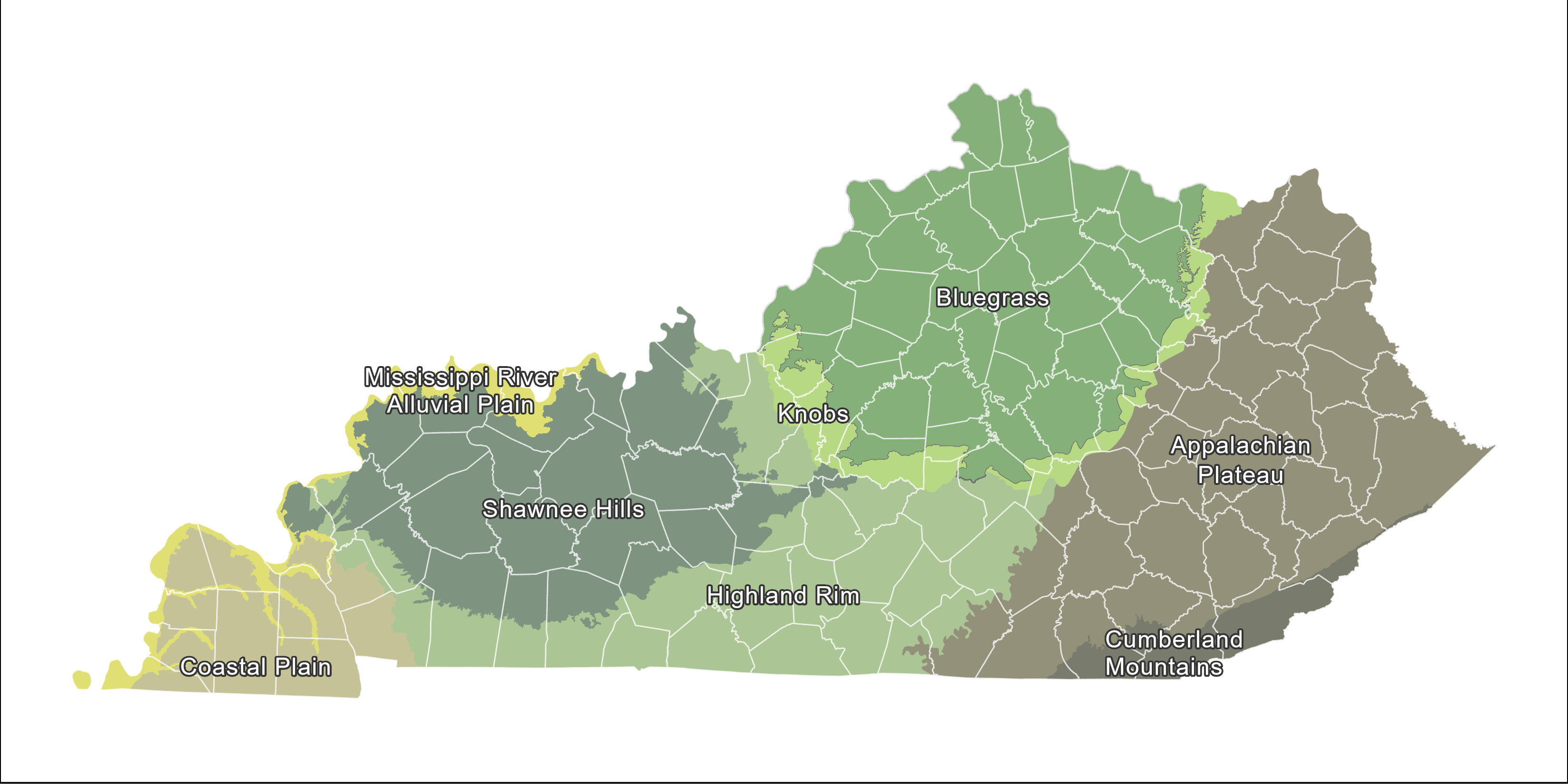
Natural Regions:
areas with broad similarity of geology, topography, hydrology, soils, climate, and vegetation. The natural regions reference layer used in this site is largely based on Abernathy et al. (2010), with modifications. Notably, the Mississippi Alluvial Plain, as displayed, consolidates two distinct natural regions: the Mississippi/Ohio River Floodplain and the Owensboro Lowlands/Ohio River Floodplain.
Phenology (plant):
flowering and fruiting periods for angiosperms and spore-producing period for lycophytes
Photo Credits:
person who took the photo
Propagation Notes (plant):
information regarding the propagation of the plant
Range in Kentucky (natural communities):
verbal description of the geographic distribution
Relation to Similar Communities (natural community):
Comparisons with similar natural communities including how to distinguish them
Scientific Name (plant):
genus and species (sometimes with subspecies or variety) in latin following the binomial nomenclature, mostly using the taxonomy of the Flora of the Southeastern United States (Weakley, 2023) and the Kentucky Plant Atlas (Campbell and Medley, 2023)
Seed Storage Type (plant):
type of seed in terms of storage requirements to maintain viability
SGCN Status (plant):
species of greatest conservation need as identified in the Kentucky State Wildlife Action Plan
Species Description (plant):
morphological description of the plant including feature important for identification
State Rank:
state conservation rank according to OKNP, see
link for definitions
State Status:
state natural heritage status designation according to OKNP
Endangered (E)
- A taxon or natural community in danger of extirpation and/or extinction throughout all or a significant part of its range in Kentucky (generally 5 or less populations or up to 10-15 populations with significant declines, threats, or a small total population).
Threatened (T)
- A taxon or natural community likely to become endangered within the foreseeable future throughout all or a significant part of its range in Kentucky (generally 10-20 populations or up to 30 populations with significant declines, threats or a small total population).
Special Concern (S)
- A taxon or natural community that should be monitored because (1) it exists in a limited geographic area in Kentucky, (2) it may become threatened or endangered due to modification or destruction of habitat, (3) certain characteristics or requirements make it especially vulnerable to specific pressures, (4) experienced researchers have identified other factors that may jeopardize it, or (5) it is thought to be rare or declining in Kentucky but insufficient information exists for assignment to the threatened or endangered status categories (generally 20-100 populations).
Commercially Exploited (CE)
- A commercially harvested taxon that is declining substantially due to harvesting practices, especially unsustainable harvest and poaching.
Historic (H)
- A taxon or natural community that has not been reliably reported in Kentucky in 20 or more years but is not considered extinct or extirpated---see next designation.
Extirpated (X)
- A taxon for which habitat loss has been pervasive and/or concerted efforts by knowledgeable biologists to collect or observe specimens within appropriate habitat have failed. Extinct species are those that have been eliminated throughout their entire range and extirpated species are those that have been eliminated from a jurisdiction (i.e., nation or state/province).
Structure (natural community):
otherwise known as physiognomy, the overall spatial distribution of vegetation in a natural community in terms of major vertical strata
Threats (natural community):
important threats that are reducing remaining acreage or impacting ecological quality
USFWS Status (plant):
protection status with the U.S. Endangered Species Act
Wetland Indicator Status (EMP and AGCP) (plant):
status that describes the probability of a species occurring in a wetland according to USACE (2022) for the two regional lists from Kentucky, Eastern Mountains and Piedmont (EMP) and Atlantic Gulf Coastal Plain (AGCP)
Natural Community Classification
Defining Natural Communities
A natural community is defined as a group of species that interact with each other and repeatedly occurs under similar environmental conditions across the landscape. Natural communities are primarily shaped by natural processes rather than modern anthropogenic disturbances. Historically, Kentucky had a wide variety of landscapes and ecosystems from cypress swamps in the far western part to large expanses of grasslands to forest covered mountains in eastern Kentucky. Since European settlement, humans have greatly altered these natural landscapes. Natural landscapes today represent a small fraction of those less altered and fairly intact ecosystems. A community classification divides the complexity of natural landscapes into distinct units that managers and conservationists can use to map landscapes and use a unified language to communicate about natural vegetation across a landscape.
It is important to keep in mind that dividing the natural world into discrete categories is inherently an artificial process and reflects human objectives. This is especially true for the process of community classification. The many different community classifications reflect different goals, such as timber management, wildlife management or landscape mapping with a variety of degrees of scale. This natural community classification is a fine-filtered approach designed to aid the conservation of biodiversity in Kentucky. At times it can be difficult to assign and map Kentucky’s highly diverse landscapes into natural communities. While the line between two types can be clear where landscape changes are abrupt, more often, landscape attributes such as soil, moisture or elevation change gradually, with different community types subtly grading into each other without a clear line.
Development of the Classification
The Office of Kentucky Nature Preserves maintains a natural community classification for the state of Kentucky that resulted from decades of extensive data collection by experts within and outside of Kentucky and replaces a draft version by Evans et al. (2009). It does not include anthropogenic systems such as agricultural fields, tree plantations, wetland mitigations, and “native grassland” plantings. While some non-vegetated communities such as aquatic or subterranean communities are included, they are still in development. This newest version is expanded and refined to include numerous additional, especially rare, community types. Additionally, most of Kentucky’s natural communities have been linked to NatureServe’s International Vegetation Classification (IVC), the most widely accepted international standard for natural community classification. This was developed through decades of working closely with ecologists throughout the country, especially the U.S. National Vegetation Classification. Our ecologists helped define new communities and crosswalk others with existing types in the IVC, resulting in a better understanding of regional community ecology and the addition of global conservation ranks to Kentucky’s communities. We currently recognize 102 natural communities for Kentucky.
Not all community descriptions are based on the same level of available data. Some community types have been thoroughly researched through qualitative inventories and quantitative plot data, whereas for others we only have limited data. This is especially true for those that are nearly extinct or have been altered by anthropogenic disturbances such as fire suppression. In coming years, we will continue study and inventory of our state’s natural communities and new data will help us further improve and add to this classification. Therefore, this classification should be considered adaptive with an expectation of continual improvement. To make our classification accessible to a broad audience, we have written the type descriptions with minimized technical jargon and limited text to key facts necessary for identifying a community type. The classification is maintained in OKNP’s Kentucky Natural Heritage Database where occurrences of rare natural communities and high-quality examples of non-rare natural communities are mapped and monitored. For those users interested in more detailed and technical information about a community type, we recommend viewing profiles maintained in NatureServe Explorer (search by ELCODE).
Natural Community Names
Community names reflect important distinguishing attributes such as region, substrate, landform, moisture regime, hydrology, structure, or dominant species. Regions can be broad or small and the exclusion of a region may indicate a presence state-wide. Substrate includes geology or soil acidity and is typically utilized when those characteristics have a profound influence on the structure and composition. Though most communities are specific to certain landforms, these are only included in names where they are highly specific or not otherwise assumed like cliff, ledge, floodplain, riparian, sinkhole/depression, etc. Moisture regime is important in all communities, but typically only used when it isn’t easily assumed. For example, wetlands and riparian areas have high moisture and most grasslands are dry, but it’s helpful for upland forests, cliffs, and rockhouses. Hydrologic terms are specific to wetland communities and indicate the nature of water in a wetland in terms of the movement and duration of soil saturation such as whether a community is occasionally flooded, permanently or semi-permanently inundated, or fed by rainwater or groundwater. Hydrology and structure are combined into specific terms commonly used in wetland community classification like swamp, seep, marsh, or flatwoods. Structure is highly important and one of the most consistent terms used in community names to help explain the dominant cover in vertical strata, especially to distinguish between the degree of canopy openness or dominance of a particular stratum. Lastly, dominant species are occasionally used in community names like wetland plants accustomed to prolonged inundation (bald cypress, tupelo, or buttonbush) or regionally specific coniferous tree species (pines, hemlocks, cedars).